Field Day – 2017 exhibition has been held in the Troitsk are of the Chelyabinsk region. Members of the agro industrial complex from different parts of the Russia and neighbouring countries gathered in the Karsi village. There were agrarians from all over the Ural federal district as well as from Moscow, Nizhny Novgorod, Kirov, Rostov and Orenburg regions, Bashkiria, Tatarstan, Udmurtia and the Republic of Kazakhstan. South Ural State University was represented by Geoinformation technologies scientific educational center.
.jpg)
The exhibition was opened by the governor of the Chelyabinsk region Boris Dubrovsky:
«I greet everyone on this holiday which marks the end of spring field work. This year the weather, as always, surprised us, made difficulties, but thanks to your work, perseverance and knowledge, the work was completed on time and with good quality», – the head of the region said.
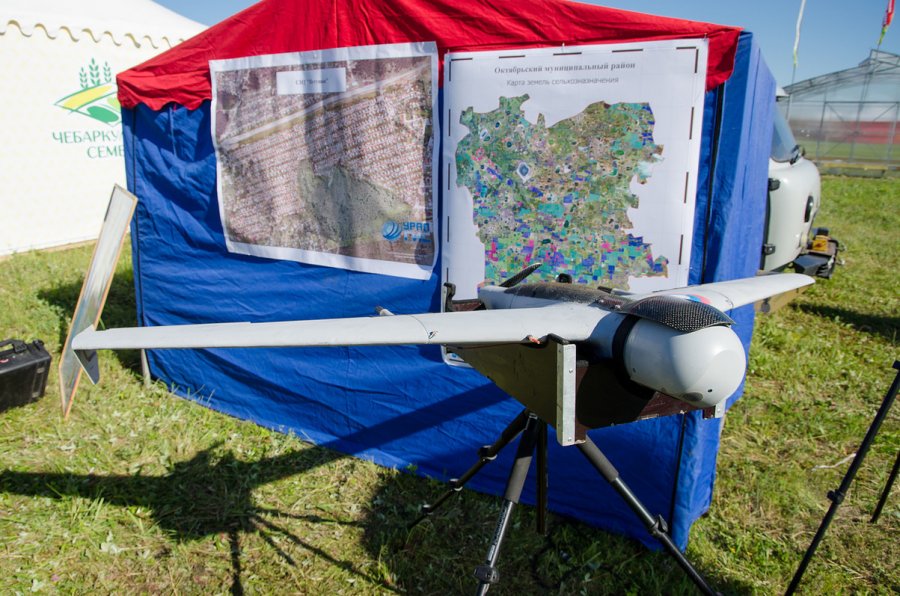
After the opening, Boris Alexandrovich inspected the latest technologies of the agricultural machinery which were presented at the exhibition. The GIS technologies of SUSU were particularly distinguished against the backdrop of agricultural machinery and equipment. Valentina Maksimova, head of Geoinformation Technologies REC, together with her colleagues presented to the governor the hardware and software complex Geoinformation Systems. This complex is used to monitor agriculture, identify uncharted, abandoned or cultivated land.
.jpg)
The complex includes several aerial drones, geoinformation systems developed both in SUSU and abroad, satellite imagery and supercomputer computations. This system is used for the government purposes. However, there is also an upgraded model.
«We made a new module for this system, made more specified technologies for the end users, for farmers who have their own fields, their own equipment. For them the system consists of daily monitoring of agricultural operations and the use of equipment by obtaining data online using ordinary tablets», – Valentina Maksimova explains.
First step is to create digital maps for the farmers with the help of drones or satellite imagery, then GPS trackers are placed on the equipment. By installing a special application on the phone or tablet, farmers will be able to see in real time how their fields are being processed. In addition, special sensors allow you to monitor fuel consumption online. In addition to simple convenience, such a system also protects against unauthorized fuel pouring off. But the main thing is, of course, the economic benefit.
For example, if we take a farmer with five units of equipment and 15-20 000 hectares of fields with the help of such sensors he will be able to save about 300,000 rubles a year on gasoline, because he won’t have to personally go to all the fields.
.jpg)
«There are serious, great prospects for GIS technologies in the agriculture. It will be possible to look over the fields, while being in another place. Launch, fly, look. It is convenient for farmers», – Alexander Saplin, head of the department for technical policy at the Ministry of Agriculture of the Chelyabinsk region, commented on the developments of SUSU.
SUSU GIS-technology at the exhibition interested the head of the Kizilsky district Alexander Seleznev. Perhaps in the near future the university's technologies will be used in this region as well.
.jpg)
.jpg)